3.1 Land use and deforestation
See Table 3.1 hereAbout the data
Definitions
Data Sources
The data indicate major differences in resource endowments and uses among countries, but true comparability is limited because of variations in definitions, statistical methods, and the quality of data collection. For example, countries sometimes use different definitions for land use. The Food and Agriculture Organization (FAO), the primary compiler of these data, often adjusts the definitions of land use categories—and sometimes substantially revises earlier data. Because the data thus reflect changes in data reporting procedures as well as actual changes in land use, apparent trends should be interpreted with caution. Increasingly sophisticated satellite images show land use different from that given by ground-based measures in terms of both total area under cultivation and type of land use. Furthermore, land use data in countries such as India are based on reporting systems that were geared to the collection of land revenue. With land revenue no longer a major source of government revenue, the quality and coverage of land use data (except for cropland) have declined. Data on forest area may be particularly unreliable.
Estimates of forest area are derived from country statistics assembled by the FAO and the United Nations Economic Commission for Europe (UNECE). In 1993 new assessments were published for tropical countries by the FAO and for temperate zones jointly by the UNECE and FAO—but with different definitions. The FAO defines natural forest in tropical countries either as closed forest, where trees cover a large portion of the ground with no continuous grass cover, or as open forest, a mix of forest and grasslands with at least 10 percent tree cover and a continuous grass layer on the forest floor. The UNECE-FAO assessment defines a forest as land where tree crowns cover more than 20 percent of the area. Also included are open forest formations, forest roads and firebreaks, small, temporarily cleared areas, young stands expected to achieve at least 20 percent crown cover on maturity, and windbreaks and shelter belts. The land use data here are based on the FAO definition of area under forests, and the forestry data on the UNECE-FAO definition.
Definitions
• Land area is the total area of the country, excluding area under inland water bodies. Arable land refers to land under temporary crops, temporary meadows for mowing or pasture, and land under market and kitchen gardens.
• Rural population density is the rural population divided by the arable land area.
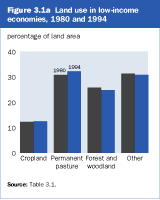
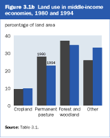
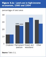
• Land use is broken into three categories. Cropland includes land under temporary and permanent crops, temporary meadows, market and kitchen gardens, and land temporarily fallow. Permanent crops are those that do not need to be replanted after each harvest, excluding trees grown for wood or timber. Permanent pasture is land used for five or more years for forage, including natural and cultivated crops. Other land uses include forest and woodland, as well as logged-over areas to be forested in the near future. Also included are uncultivated land, grassland not used for pasture, wetlands, wastelands, and built-up areas—residential, recreational, and industrial lands and areas covered by roads and other fabricated infrastructure.
• Forest area refers to land under natural or planted stands of trees, whether productive or not (see About the data).
• Annual deforestation refers to the permanent conversion of natural forest area to other uses, including shifting cultivation, permanent agriculture, ranching, settlements, or infrastructure development. Deforested areas do not include areas logged but intended for regeneration or areas degraded by fuelwood gathering, acid precipitation, or forest fires. Negative numbers indicate an increase in forest area.
Data on land area and land use are from the FAO’s electronic files. They are also published in the FAO’s Production Yearbook. The FAO gathers these data from national agencies through annual questionnaires and by analyzing the results of national agricultural censuses. Forestry data are from the World Resources Institute, which compiles data from the FAO and the UNECE.