| |
|
The political economy of development |
|
| Home- Themes- Reports- Statistics/Search- Lecture notes/News- People's Century- Puro Chile- Mapuche |
| Make your work easier and more efficient installing the rrojasdatabank toolbar ( you can customize it ) in your browser. |
|
| World indicators on the environment | World Energy Statistics - Time Series | Economic inequality |
|
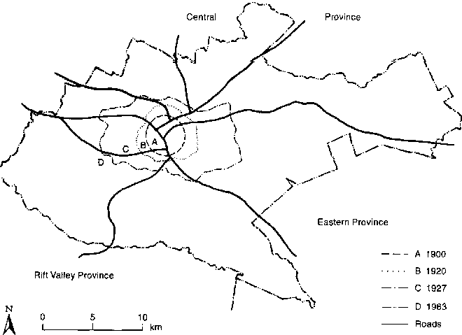
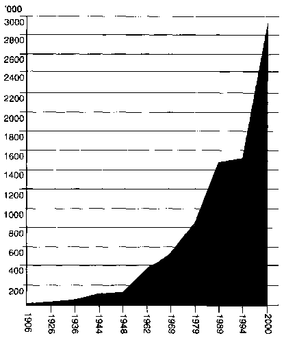
The urban challenge in Africa: Growth and management of its large cities Edited by Carole Rakodi - United Nations University Press - TOKYO - NEW YORK - PARIS - ® The United Nations University, 1997 9 Nairobi: National capital and regional hub R. A. Obudho Abstract Etablie par les colons anglais Ó l'intķrieur du Kenya au c£ur du rķseau ferroviaire est-africain, puis comme capitale du Kenya, Nairobi compte aujourd'hui environ 1.5 millions d'habitants. Bien que le Kenya soit indķpendant depuis 1963, nombre des caractķristiques spatiales et institutionnelles de Nairobi portent encore la marque de la sķgrķgation raciale de l'ķpoque coloniale et les autoritķs locales vent structurķes sur le modĶle britannique. Capitale d'un pays colonial, Nairobi a une population comptant plus de 40 per cent d'Europķens et d'Indiens jusqu'Ó l'indķpendance, chiffres qui ont probablement diminuķ depuis en termes relatifs mais pas en termes absolus. Dans les annķes suivant l'indķpendance, le Kenya essaye de s'industrialiser et le secteur de l'emploi former augmente rapidement avec une multiplication des emplois de fonctionnaires. Mais depuis de nombreuses annķes, la crķation d'emplois salariķs ne suit par le rythme de la croissance de la force de travail, tendance encore exacerbķe par les crises ķconomiques et les rķformes d'ajustement structurel des annķes 80 et 90. Dans l'impossibilitķ de travailler dans le secteur former, nombreux vent ceux et celles qui se consacrent aux activitķs du secteur informer, y compris les manufactures, le commerce et les services. Certaines de ces entreprises ont des profits respectables, mais pour la plupart d'entre elles, il s'agit simplement de survivre, de gagner au mieux de quoi subsister. La pauvretķ citadine, dont tķmoigne le nombre croissant d'enfants des rues, a dramatiquement augmentķ ces quinze derniĶres annķes. Nairobi a tour Ó tour ķtķ administrķe par un Conseil ķlu et par une Commission dķsignķe Ó cet effet. La situation politique volatile est liķe Ó des rivalitķs de classes et d'ethnies et Ó un marchķ immobilier fortement commercialisķ. La propriķtķ est le plus souvent privķe, tenue en propriķtķ perpķtuelle et libre ou louķe par l'╔tat. Par consķquent, obtenir un terrain est difficile pour toute personne n'ayant pas accĶs aux voies officielles, qu'elle manque de ressources financiĶres, qu'elle soit arrivķe en ville au mauvais moment ou qu'elle ne dispose pas d'appuis bien placķs. C'est pourquoi la majeure partie de la population s'est installķe vaille que vaille sur des terrains de propriķtķ incertaine, manquant de services et le plus souvent surpeuplķs. Nombre de rķsidents de ces ķtablissements et autres logements "Ó foyers modķrķs" n'occupent qu'une seule piĶce. La centralisation du pouvoir, l'insuffisance des revenue locaux, la mauvaise rķcupķration des co¹ts, la capacitķ limitķe des administrations locales, la croissance dķmographique rapide, l'urbanisation sauvage et l'adoption de normes inutilement ķlevķes, tout a contribuķ Ó l'insuffisance des logements et des infrastructures par rapport aux besoins et Ó de graves inķgalitķs entre les groupes sociaux. Les problĶmes ķcologiques et sanitaires s'aggravant en mĻme temps que les insuffisances des infrastructures, la pauvretķ est en augmentation, et les administrations locales et centrales ne peuvent rķagir de fańon efficace. Il faudrait mieux administrer la croissance urbaine, amķliorer la gestion financiĶre et institutionnelle, mettre en place des programmes plus efficaces de promotion de la construction de logements et de services, appuyer le secteur informer et adopter des politiques et programmes ķcologiques plus systķmatiques. Introduction Urbanization in Kenya has a long history in the coastal region but a short history in the interior parts of the country (Obudho, 1982, 1983, 1992, and 1994). The pattern that exists today predominantly reflects the development of British colonization rather than traditional African settlement patterns. The proportion of the population living in urban areas has increased from 8 per cent at independence in 1963 to 20 per cent in 1995. In 1948, there were 17 urban centres with an aggregate population of 176,000, of which 83 per cent was concentrated in Nairobi and Mombasa. By the 1962 population census, the number of urban centres had doubled to 34 and their population had increased to 671,000. In 1979, the overall proportion living in urban areas had risen to 9.9 per cent, with Nairobi accounting for 36 per cent of the total. The 1979 census indicated 90 urban centres with a total urban population of 2.3 million, which increased to 3.7 million in 1989. The 1989 population results indicate that 18 per cent of the population resided in urban areas. A total of 139 urban centres were reported, of which Nairobi was still the largest, with a similar proportion of the total (36 per cent) as in 1979. The current profile of the city of Nairobi has, in turn, been shaped by geographical, historical, and contemporary forces.1 I shall first describe Nairobi's location, historical development, and population growth. The system of land tenure and administration, which has influenced the pattern of urban development, will then be outlined, followed by aspects of the city's economy and socio-political structure. Next, the provision of urban services will be analysed, with particular reference to housing, water, solid waste disposal, transportation, and recreation. Following a discussion of environmental and health problems, the final section will suggest appropriate strategies for the future development of the city. Site and situation Nairobi is situated at the south-eastern end of the agricultural heartland of Kenya and most of its energy and food requirements can be obtained within a short distance of the city. The immediate environment of Nairobi consists of the productive highland area extending northwards and westwards to embrace the rich farming lands of the Rift Valley. Within a radius of about 10 km from the central business district (CBD), vegetables, fruit, herbs, flowers, and fuelwood are produced. Beyond this zone and in the suburbs, commercial ranching is carried out for the production of milk and meat, to be consumed by Nairobi residents. In addition to the upland agriculture, there is also active, although illegal, cultivation within the city limits (Freeman, 1991; Lado, 1990). The settlement's administrative boundaries were extended as its population increased from 8,000 in 1901 to 118,579 by 1948 (figs. 9.1 and 9.2). At the time of independence in 1963 the population had grown to an estimated 350,000, although much of the growth was due to the major boundary extension, which increased the urban administrative area to 690 (km▓) The city's 1994 population was estimated to be 1.5 million and its current growth rate to be about 5 per cent per annum (Republic of Kenya, 1994), with a population of between 2.8 and 4.0 million persons expected by the year 2010. Nairobi is likely to continue leading in terms of absolute population size, although its rate of increase is below the average urban population growth rate, which is estimated to be 7.7 per cent per annum for Kenya as a whole. Continued growth of the city has been taking place in the face of renewed strategies towards decentralized planning, which focus on the promotion of small and intermediate urban centres (Obudho, 1992). Fig. 9.1 Nairobi: Boundary changes, 1900-1963 (Source: Obudho and Aduwo, 1992, p. 53)
Fig. 9.2 Nairobi's population growth, 1906-2000 (Source: See table 9.1. Projection by author)
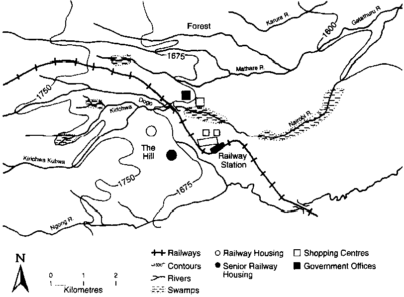
Historical background The site of Nairobi was chosen by the Kenya Uganda Railway (KUR) authorities because it offered a suitable stopping place between Mombasa and Kisumu; adequate water supply from the nearby Nairobi and Mbagathi rivers; ample level land for railway tracks and sidings; elevated cooler ground to the west suitable for residential purposes; and apparently deserted land offering freedom for land appropriation. Another primary consideration for the selection of the site was that the place was free from tropical diseases, especially malaria. The new settlement was named after the Maasai name Enkare Nairobi, which means "a place of cold waters," although there was no permanent African settlement since the place was grazing land and a livestock watering point. In 1896, a small transport depot was established at the site to keep provisions for oxen and mules (White et al., 1948, p. 10). The railhead reached the site in June 1899 and by July it had become the KUR headquarters (Boedecker, 1936; White et al., 1948; Foran, 1950, p. 220; Hallman, 1967, pp. 1428; Hake, 1977, p. 20; Obudho and Aduwo, 1992). By the end of 1899 the Government of Kenya (GOK) had selected a site on the high ground on the northern side of the Nairobi River and away from the railway station to be the administrative headquarters (Morgan, 1968; see fig. 9.3). In 1900, the Nairobi Municipal Community (NMC) regulations were published by the GOK and these defined the urban centre as "the area within a radius of one and a half miles from the offices of the sub-commissioner of the Ukambani Province" (Morgan, 1976, p. 100; see fig. 9.1). A small number of settlers had begun settling in the urban centre by then and, with the construction of the KUR on the move, it became essential to designate a mid-way site where a well-equipped maintenance depot could be built. The then Engineer stated that:
Once the KUR authorities had made the decision to locate a depot in Nairobi, spatial patterns around it and the railway station emerged. Europeans established their homes on the hill to the west, away from Asians and Africans (fig. 9.3), soon leading to exclusive European residential settlements. Meanwhile, Asian employees who had been discharged from KUR employment established shops not far from the railway station, an area that came to be known as the Indian Bazaar. The Asian buildings were used both for business and as living quarters by a few Africans who worked for the KUR, while others lived in employee housing and shanty villages to the east (White et al., 1948). By 1906 the original KUR depot and camp had grown into an urban centre of over 10,000 people and definite land-use zones had appeared, though these had not been planned, with the Europeans mainly occupying the cooler westlands, the Indians in the north, and the African workers mainly concentrated on the periphery (fig. 9.4). With the completion of the KUR and the influx of more non-African settlers, the settlement expanded rapidly. By 1909 much of its internal structure, especially the road network in the CBD, was already established. Fig. 9.3 Nairobi circa 1900 (Source: White et al., 1948, p. 11)
In 1919, the Nairobi Municipal Community was replaced by Nairobi City Council (NCC). At the same time the boundary was extended to include pert-urban settlements (Croix, 1950, pp. 23-24). The boundary was again extended in 1927 to cover 30 square miles (White et al., 1948; see fig. 9.1). From 1928 to the time of independence of Kenya in 1963, this boundary remained the same, with only minor additions and excisions taking place. By 1950, permanent residential zones had already been demarcated, very much along the lines first established in the early years of the century. In 1963, the boundary of Nairobi was further extended and remains the same today (fig. 9.1). Expansion was expected to take place within this area, mainly on the 20 square miles of black cotton soil and ranching land to the east of the early settlement (Ferraro, 1978). Population growth and dynamics The population of Nairobi grew from 10,512 in 1906 to 118,976 in 1948 (table 9.1). By 1962, it had a population of 266,795 people. Between the 1948 and 1962 censuses, the population grew at an average rate of 5.9 per cent per annum, compared with 7.6 per cent in the previous 12-year period. The African and Asian population grew hand in hand with the total population until 1960, with the former making up just under 60 per cent and the latter one-third of the total (table 9.2) (Obudho and Muganzi, 1991). A decline in the number of Europeans and Asians resulted from emigration following independence (Tiwari, 1972 and 1979) and these groups formed only 4 per cent and 14 per cent, respectively, of the city's population in 1969, falling to 1 per cent and 4 per cent, respectively, in 1989. Fig. 9.4 The segregation of residential areas in Nairobi, 1909 (Source: Mazingira Institute, 1993, p. 2)
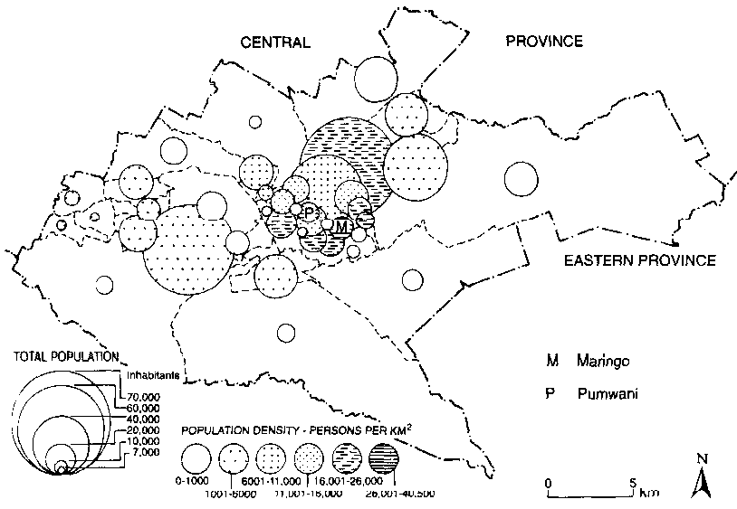
A feature of the post-independence period has been the movement of people from the rural areas to Nairobi. The main sources of short-distance migrants are the districts of Central Province, while long-distance migrants come from the Eastern, Western, and Nyanza Provinces. The 1989 census put the city's population at 1.3 million, 80 per cent of whom are accommodated on 20 per cent of the land. Population is heavily concentrated in a number of inner-city wards, in some of which, such as Pumwani and Maringo, densities are extremely high (over 26,000 people per (km▓) see fig. 9.5). Alternative projections to 2010 range from 2.8 to 4 million (Mazingira Institute, 1993; Obudho and Aduwo, 1992, p.57) and it is estimated that 550,000 families will need to be sheltered by the year 2000 (Republic of Kenya, 1993). This increase has and will continue to exert a lot of demands on the environment unless adequate measures are taken. The population of Nairobi is predominantly male. In 1962, there were over twice as many adult males as females, so that the sex ratio (including children) was 250 males to 100 females but with striking differences among racial groups. Although the numbers of women and men have become somewhat more even since then (table 9.3), the continued predominance of men in Nairobi can be attributed to the fact that the majority of rural-urban migrants are men. Table 9.1 Nairobi: Population for selected years, 1906-1994
a. Estimated. Table 9.2 Nairobi: Population by race for selected years, 1906-1989
Fig. 9.5 Nairobi: Population distribution and density by ward, 1979 (Source: Obudho and Aduwo, 1992, p. 57)
Table 9.3 Nairobi: Sex ratios, 1948-1989
Table 9.4 Nairobi: Primacy index, 1948-1989
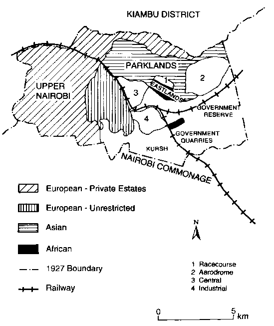
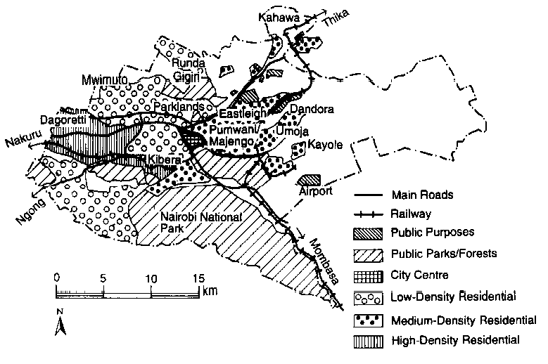
Nairobi's primacy in Kenya's urban settlement size distribution has increased rapidly since independence, as expressed by a four-city index (table 9.4), which shows that the city's population as a percentage of the population of the four largest centres increased from 98 per cent in 1948 to 142 per cent in 1989, even though its proportion of the total urban population fell from 42 per cent to 36 per cent as the growth rate of smaller urban centres increased (Obudho, 1993a). Nairobi's primacy has been sustained by the economies of agglomeration offered to enterprises by locating in the city (Obudho and Aduwo, 1992), despite the attempts of the GOK to deconcentrate urbanization and facilitate more balanced spatial development. Some programmes have aimed at reducing migration to Nairobi through such instruments as tax incentives, limitations on investment, and demolition of slum and squatter settlements. The last policy was designed to force residents to resettle in rural areas. The GOK also promoted regional centres by extending support services to them, improving infrastructure, and strengthening the linkages between these centres and Nairobi. Integrated rural development programmes were implemented to provide agricultural inputs and social services, increase infrastructural investments, and improve agricultural productivity and incomes. These policies and programmes failed to affect population distribution significantly and Nairobi has continued to grow rapidly. The reasons for the insignificant impact of these policies vary, depending upon the economic and political context. Two reasons, however, seem to be the most common. First, the objectives of spatial strategies were not adequately reflected in GOK sectoral decisions, which shaped public and private investments. Thus, the programmes were insufficient to offset market forces that overwhelmingly favour concentration of social and economic activities in large urban centres. Rapid growth of Nairobi since the 1950s has been associated with several negative consequences: an increasing incidence of urban poverty, inadequate access to housing and such basic services as primary health care and water supply, the proliferation of slums and squatter settlements, and urban environmental degradation, among others. In an attempt to tackle these problems and improve the distribution of population within the city region, so-called accommodationist policies and programmes attempted to improve urban housing and services and deconcentrate the growth of Nairobi by promoting dormitory and satellite urban centres around it (Obudho and Aduwo, 1992). Land tenure, use, ownership, and management Nairobi was born out of colonial policy to build the KUR. Before the railway line could be laid, legal decisions had to be made regarding the ownership of the land covered by it. The British government anticipated land-title disputes, because its experiences in India and other places had demonstrated that speculators could take advantage of the need for land and thereby increase the cost of constructing the railway. In addition, possible future conflicts between the indigenous peoples and the British had to be guarded against. The British authority assumed the power to obtain any land without regard to indigenous territorial claims, particularly along the whole route covered by the railway. The land was taken over by the Crown, which had the responsibility of subdividing it. Land-use patterns became well defined, reflecting the commercial and residential segregational policies pursued by the colony. By 1902, the reservation of areas for European settlement had been adopted and all of the western part of Nairobi was allocated for Europeans (fig. 9.4). This explains why the western and northern parts of the city are still in the hands of private individuals. There were also policies to segregate land allocation in the commercial areas. However, these efforts failed because the European businessmen needed Asian and African customers if they were to continue in business. Much of Nairobi's land, including the CBD, is publicly owned and leased to private owners, usually for 99 years (Ondiege, 1989). GOK leasehold covers most of the legalized residential areas, and corporate ownership of land in these areas has become increasingly widespread. Freehold land is privately owned either by individuals or by groups of individuals and can be put on the market for sale without limits to the period of ownership. This covers a small portion of Nairobi's land, being found in the western and north-western suburbs in areas such as Dagoretti, Mwimuto, Runda, and Gigiri (fig. 9.6). It also covers part of the Kahawa area in the north. Overall, over half of the city's area was estimated to be in private ownership in 1993 (Karuga, 1993, p. 22). A number of the larger illegal residential areas are found in these freehold zones (Ondiege, 1989; see fig. 9.7). GOK land forms the second-largest portion of Nairobi (40 per cent in 1993). This includes Nairobi National Park and other major parks and forest areas, airports, Kenyatta and Nairobi universities, and Kamiti prison. The NCC owns 5 per cent of the total, mostly in the east (Karuga, 1993, p. 22). However, in practice, the public sector has very little direct control over land available for development (Macoloo and Maina, 1994). Between 1911 and 1914 Asians were allowed to acquire control of areas to the north-east of the town centre (including Eastleigh), which were at the time located outside the urban boundary. In 1920 the boundary was adjusted to incorporate land that had been alienated by the GOK for residential purposes. The new boundary showed the line between the GOK's land and the private estates that had been alienated as homesteads. Fig. 9.6 The urban structure of present-day Nairobi
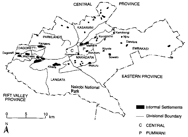
Fig. 9.7 Nairobi: Informal settlements, 1992 (Source: Obudho, 1992, p. 100)
Land and property prices in Nairobi reflect the quality of residential neighbourhoods. This pattern has largely developed from the colonial land segregation policies, hence land that was allocated to non-Africans in the western part of Nairobi is highly valued. The pattern has also been affected by the density of people residing in various areas, with high-density areas showing low prices. The CBD has the highest land prices, because of its intensive commercial use. The industrial areas (light industries) also have high land values. Whereas land in the CBD might, in 1994, have a value of KSh10 million per acre, its price in the light industries area was KSh1 million per acre. The prime residential areas are generally located in the western part of Nairobi, although parts of the northern section of the city have equally high land values. The eastern and northern parts of Nairobi generally have lower land prices. The eastern part of the city is generally flat land with black cotton soils, which are less attractive to residential development than the cooler, hilly areas in the west. Access to land in Nairobi is controlled by legislation governing its use, allocation, and management. The land-use planning framework has been provided by the Nairobi Urban Study Group's report of 1973 (NCC, 1973). However, the process of land allocation is fraught with corruption and disregard for regulations and planning standards. Both the general public and private agencies ignore the regulations and this has led to irregular developments. Developers, for instance, have put up high-rise blocks and extensions in areas where such developments are prohibited by law. Slums and squatter settlements have also developed, and subdivision is occurring outside the boundary (Obudho and Aduwo, 1989; see fig. 9.7). The NCC is endowed with extensive development control powers but these have not been effectively enforced. As a result, current zoning patterns no longer protect the quality of life and the resulting environment is costly to maintain and service (Karuga, 1993). Publicly owned land has also been allocated to private individuals, who have erected illegal structures, leading to a shortage of land for public developments. The repossession of such land has met with political resistance, as the individuals allocated such land have called on their patrons for support. The Nairobi City Convention held in 1993 recommended a special task force to deal with land use and allocation procedures to help ensure that planned developments follow the legal guidelines (Karuga, 1993). Political economy Employment Of people in Nairobi aged between 15 and 50, 63 per cent are economically active (Mazingira, 1993, p. 5). Since independence, there has been considerable growth in wage employment in the modern sector. Access to formal sector employment improved considerably in Nairobi, whereas it worsened in the rest of the urban centres in Kenya, with the result that Nairobi dominates urban formal sector employment. Nevertheless, the growth of jobs has not kept pace with that of the labour force. In 1992, formal wage employment in Nairobi was 376,200 persons (73 per cent of those working). However, there has been a decline in wage employment in the public sector in Kenya owing to the restructuring and privatization programme introduced in 1990. Wage employment in Nairobi includes the following: in 1992 66,600 of Nairobi's labour force were in manufacturing industry; 36,300 in building and construction; 47,300 in trade, restaurants, and hotels; 41,300 in finance, insurance, real estate, and business services; while community, social, and personal services employed 136,800 people (Republic of Kenya, 1993, p. 55). The livelihood of most dwellers in Nairobi comes from regular wage employment and, although it is likely that the proportion in formal sector employment is decreasing, estimates of the size of the informal sector vary. The 1992 Economic Survey, for example, showed that there were 141,877 persons engaged in the informal sector (an apparent 27 per cent increase over 1991). The high rate of growth is a consequence of increased demand for goods and services (Republic of Kenya, 1993), although the informal sector also acts as a safety-valve. The activities in this sector range from painting, carpentry, shoe making, driving, and domestic service to petty trading and hawking of various food commodities. Informal income-generating activities can perhaps best be thought of as the unregulated and unprotected production of goods and provision of services by those with relatively little capital. Earnings from many informal sector activities in Nairobi compare favourably with those from urban unskilled or rural agricultural wage employment. The formal and informal sectors are generally thought to be symbiotic, with the vitality of the informal sector depending upon the wages and demand generated by formal sector (House, 1978). The most important way in which women generate income in the informal sector is through the marketing of farm and marine products, as well as of imported manufactured goods. The first category is comprised of women engaged in trade at either retail or wholesale level, mostly in the low-income zones. Some sell in large quantities and regulate the major supplies to urban areas. The majority engage in retail trade in small kiosks that sell consumables. Others are engaged in distributing sisal products such as ropes for making "kiondos," a type of local basket. The second category comprises urban women who sell a wide variety of goods ranging from food and jewellery to imported new and old shoes and clothing. They sell hair products and engage in hair styling. These women are to be found in the medium-income zones in Nairobi (Mwatha, 1988). The informal sector contributes significantly to Nairobi's economy and has strong backward linkages with commercial and public enterprises. The creation of employment opportunities in this sector is not necessarily dependent upon direct public expenditure and commitment of public investment in advance. The other advantages of the informal sector are that it uses simple technology appropriate to the resource base of the communities and that it produces jobs at lower costs. Despite the growth of this sector, unemployment is particularly widespread among young urban dwellers and women. Poverty Poverty in Nairobi is as old as the city itself. A growing portion of residents could be termed "poor." Currently the population is categorized into low-, middle-, and high-income groups. In 1983, 60 per cent earned less than KSh2,300 per month, 20 per cent earned between KSh2,300 and 3,700 per month, and the remaining 20 per cent had a monthly income of over KSh3,700. Those who earned less than KSh2,300 accounted for only 24 per cent of the total income in the city, whereas those in the next income group accounted for 21 per cent, and the last group for 56 per cent of total income (Syagga and Kiamba, 1988). The low-income group is comprised of drivers, watchmen, clerks, and typists, among others, in formal sector employment. Those in the informal sector include street hawkers, metal artisans, shoe shiners, construction workers, and street cleaners. Households in this group spent more than 56 per cent of their income on food in 1983 (Mazingira, 1993, p. 7). They walk to their places of work because they cannot afford bus fares every day. On average, households in this group spent 14 per cent of their income on rent in informal sector housing, in comparison with 20 per cent and 17 per cent for the middle- and high-income groups respectively. Under the Structural Adjustment Programmes (SAPs), inflation in Kenya went up significantly from 15.8 per cent in 1990 to 19.6 per cent in 1991 and 27.5 per cent in 1992 (Republic of Kenya, 1993). The first quarter of 1993 was marked by a general increase in consumer prices. As a result, the month-on-month rate of inflation in Kenya was recorded at 32.4 per cent in January 1993, rising to 41.9 per cent in February 1993 (Republic of Kenya, 1993, p. 4). Among the factors contributing to the inflationary pressures were price decontrol, the withholding of foreign donor aid to Kenya, the use of foreign exchange certificates in importing goods and services, increases in administered prices, devaluation of the Kenyan shilling, and rapid monetary expansion (Republic of Kenya, 1993). The lowiincome group has been the most seriously affected by the inflationary trends since 1990. In addition, a substantial number of middle-income households have been pushed into the low-income category. According to the revised Nairobi consumer price indices, the cost of living for all income groups has more than doubled from its 1987 level. Street children A major consequence of urbanization and poverty is the existence of "street children" (Ayako, 1994; Aptekar et al., 1994). In Nairobi, the term "parking boys" is used to refer to such children, being derived from one of their most common activities, which is directing motorists to available parking spaces along the crowded kerbs during peak hours. The children guard the cars until the drivers return. Their tips depend on the generosity of the drivers. The problem of street children is increasing in Nairobi. It is illegal to mistreat dependent children and it is also illegal to assault, neglect, or abandon children. Parents who do so are liable to arrest, but in most cases the authorities merely arrest children for loitering or wandering aimlessly and put them in foster homes. One of the major reasons for the increase in the number of street children in Nairobi is the stark poverty that drives parents to neglect, ignore, and finally abandon their children; a good number of children are left to fend for themselves when their parents are arrested and sent to jail; some parents leave their children to drift aimlessly without proper adult supervision and there is said to be a breakdown of family life as a result of the urbanization process. The problem of street childen in Nairobi is serious and needs to be thought about carefully by the GOK, individuals, and nongovernmental organizations (NGOs). It is important to devise lasting solutions. One method of improving the welfare of street children is by allocating land to their parents, many of whom are landless women. However, generally it is not good enough to have street children from Nairobi resettled in a rural area since they are not part of that community. While trying to improve the well-being of the children, their sense of dignity and pride must be maintained. In most cases an educational approach will be most fruitful. Rehabilitation centres for street children providing education, literacy, and vocational training should be located in their neighbourhoods, where the children can identify with the community's aspirations. The street children must be encouraged to be independent so that they do not rely on other people or on free donations. It should be remembered that many street children have survived on their own. Unless this trend is changed, the majority of street children in Nairobi will also be parents of street children, in which case we are building a culture of poverty. The structure and system of government The Nairobi City Council (NCC) is supervised by the central government through the Ministry of Local Government. The NCC performs mandatory functions such as provision of public health and primary educational facilities, maintenance and repair of urban roads, and burial of destitutes, as well as permissive functions, which include administrative activities, sewerage and drainage, water supply, collection of garbage, markets, and social welfare services. The relationship between the central government and the NCC is an advisory one, with the Minister of Local Government having veto powers. The day-to-day operations of the NCC are carried out by the mayor and his elected councillors. There are also nominated councillors who are co-opted onto the NCC. Politics has had a lot of impact on the delivery of services to urban dwellers. At independence in 1963, Nairobi was a fully fledged urban centre run by an elected council. However, the council was dissolved in 1983 and replaced by a Nairobi City Commission. For nine years, Nairobi was run by various appointed commissioners. In 1992, the City Council was reconstituted and it is now run by an elected mayor and councillors who are members of different political parties. The politics of Nairobi is currently dominated by opposition parties. Whether elected or appointed, the local government has failed to cope adequately with the growth of the city. The problems can, inter alia, be attributed to a lack of resources, bureaucratic lethargy, corruption and indiscipline, lack of clear lines of authority, and disregard of public opinion. Ethnicity and racial groups Nairobi is comprised of a variety of ethnic communities, with considerable diversity of language, organizational systems, historical experience, and ways of life (Werlin, 1974). The non-African communities in Nairobi also have distinct organizational and cultural systems. The colonial GOK set up administrative units to coincide with ethnic units, with Africans employed as civil servants usually in their own ethnic area. In each section of Kenya, the British set up native courts, using the customary laws prevailing in the area and giving local chiefs or elders executive as well as judicial powers. This meant that those who moved into new areas were generally considered ethnic strangers and, as such, prevented or discouraged from acquiring property and in other ways discriminated against. The location of schools, urban centres, and commercial undertakings was such as to benefit some ethnic groups more than others. This type of approach still prevails in Nairobi to a more limited extent. In addition, the colonial government consciously or unconsciously used one ethnic group against another. For example, the British recruited Kamba, Kipsigis, and Kalenjin ethnic groups for army and police work against the Kikuyu, whom the British saw as the primary threat to colonial rule. Through the denial of opportunities for trans-ethnic politics and the discouragement for many years of African nationalist parties, political organizations, and newspapers, the British left the way open for ethnic parties and associations. Likewise, with the belated introduction of extensive African legislative representation through popular elections, local politics with an ethnic orientation prevailed. Since there were few experienced African administrators, judges, politicians, and military or police officers, there was a dearth of respected Africans who could mediate interethnic disputes or could handle problems that generated inter-ethnic conflict. Moreover, most Africans lacked the integrative experience of formal education, including the learning of a common language, the forming of multi-ethnic friendships, and the development of ethnically cross-cutting associations. At independence, the Kenya African National Union (KANU) came to be increasingly dominated by Kikuyu and Luo. As such, it could hardly mediate inter-ethnic disputes. Likewise, because the struggle for political power was so intense, elections could not be used to resolve inter-ethnic conflict peacefully. At the same time, the legislature, bureaucracy, judiciary, army, and police were no longer considered ethnically neutral. Although inter-ethnic tension had always existed in Nairobi, the manifestations became more serious with independence. There was overwhelming evidence of ethnic discrimination. Conflict arose from the fact that, because of ethnic prejudice, certain groups seemed to be getting ahead faster than others. Tension between the Luo and the Kikuyu was the most obvious. Ethnic favouritism in job allocations was undoubtedly the greatest source of animosity in view of the existing urban poverty and unemployment. Management of urban services in Nairobi has been worsened by inter-racial and inter-ethnic conflict originating to a large extent in the colonial period. This, of course, adversely affects the attainment of the cooperative relationship necessary for successful decentralization and management of urban services. What intensifies social conflict in Nairobi is the existence of a large group of poor people alongside a wealthy minority. Amid poverty and unemployment, great pressure is put on those in power to distribute jobs and favours to members of their own ethnic group. As this happens, there is an intensified resentment of ethnic favouritism on the part of the politically disadvantaged. Political party affiliation is currently playing a determining role in the appointments to local government and even civil service positions. Distrust resulting from party affiliations and such appointments is dysfunctional in a number of ways; for example, the various political party groupings into which the NCC members and employees are divided do not trust one another and those associated with the NCC are distrustful of those associated with central government. This impedes the communication process necessary for administrative efficiency and results in the inordinate prolongation of committee meetings, upon which the functioning of the NCC depends. Chief officers sabotage decisions of councillors and the mayor, and vice versa. In this way, technical decisions or advice of the officers come to be viewed as politically motivated. Such conflicts have affected the policy-making process, reduced the operational effectiveness of the NCC, and reduced its ability to provide services to residents (Karuga, 1993). The non-Africans, such as Asians and Europeans, however, have kept away from politics by spending most of their time in business. But because they control wealth they also exercise some influence over Nairobi politics. | ||||||||||||||||||||||||||||||||||||||||||||||||||||||||||||||||||||||||||||||||||||||||||||||||||||||||||||||||||||||||||||||||||||||||||||||||||||||||||||||||||||||||||||||||||||||||||||||||||